THE “GRAY” SITE:
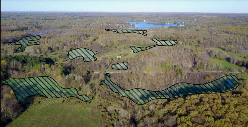
Above is an annotated engineering drawing for the "Gray" site. Its distorted shape resulted from "shoe-horning" it between adjacent wetlands. Those wetlands have active surface drainage via two small creeks into Bullkill Marsh, approximately200 yards to the west, which in turn flows north to the Muskegon River.
We consider the selection & development of this site to be Michigan Potash's most serious blunder to date. Little more than 6 acres in size, it is slated to contain 8 production injection-wells, and 2 waste injection wells, along with all of the pipes, tanks, pumps, valves, and associated facilities needed to interconnect them and to a proposed refinery 3⁄8 mile away. These facilities will transport tens of thousands of gallons per minute of concentrated corrosive brines at pressures of 2,000 pounds per square inch. This site would serve as the hub of MPSC’s entire operation and is the most likely place for leaks and spills to occur. According to Michigan Potash CEO Ted Pagano: “I cannot guarantee that there will not be a catastrophic failure.” Such an occurrence would devastate Bullkill Marsh & Creek for decades to come.
In view of the clear risks to the state’s natural resources, it is incomprehensible that EGLE would allow these activities to proceed on this site!
It’s important to consider that MPSC says they will produce 1 million tons of potash per year. To accomplish this,
they will need a minimum of 36 wellheads, all running “full-bore” and at optimal conditions1 (realistically, they
will probably need more than twice that number). Where will they put all of those additional wellheads?
WHY DID THEY PICK THE MOST VULNERABLE PIECE OF GROUND THEY OWN FOR THIS PURPOSE?